CCTV News:According to the Central Meteorological Observatory, it is expected that in the next three days, attention will be paid to the development trend of typhoon "Little Dog" and the influence of wind and rain, and there will be strong wind disaster risks in the coastal areas of South China and the South China Sea.
Typhoon "Little Dog" will affect the southeast coast.
Typhoon KOINU, the 14th typhoon this year, was upgraded from typhoon level to strong typhoon level this afternoon (6th). At 5pm, its center is located in the northeast of the South China Sea, about 200km southeast of Shanwei City, Guangdong Province, which is 21.5 degrees north latitude and 116.7 degrees east longitude. The maximum wind force near the center is 14 (42m/s), and the lowest pressure at the center is 955 hectopascals, which is 7. It is estimated that "Little Dog" will move to the south-west direction at a speed of 5-10 kilometers per hour, and its intensity will be maintained or slowly weakened, and it will gradually approach the coastal area from the west of Guangdong to the east of Hainan Island.The Central Meteorological Observatory continued to issue a yellow typhoon warning at 18: 00 on October 6..
Affected by typhoon "Little Dog" and cold air, it is estimated that there will be strong winds of 6-8 grades and gusts of 9-10 grades in most parts of the East China Sea and the waters near Diaoyu Island, the Taiwan Province Strait, the northern part of the South China Sea, the coastal areas of Zhejiang, Fujian and Guangdong, among which there will be strong winds of 9-11 grades and gusts of 12-13 grades in parts of the coastal areas of Guangdong and the northern part of the South China Sea. From 20: 00 on the 6th to 20: 00 on the 7th, there will be heavy rain or rainstorm (50-65mm) in the southeast of Fujian and the east coast of Guangdong. From the night of the 6th to the day of the 9th, there was strong wind and rain in the coastal areas of eastern and southern Guangdong and central and southern Fujian.
Rain and snow weaken in the western region
From the night of the 6 th to the day of the 9 th, there were rainfall processes in southern Gansu, Sichuan, Chongqing, most of Guizhou, Yunnan and other places, and some areas had moderate to heavy rain; There are small to medium snow or sleet in eastern Tibet, southern and western Qinghai, and there is heavy snow locally.
Specific forecast for the next three days
From 20: 00 on October 6 to 20: 00 on October 7,There are small to medium snow or sleet in the western mountainous area of southern Xinjiang basin, southern Qinghai and eastern Tibet; There are moderate to heavy rains in parts of southeastern Tibet, eastern and southern Sichuan Basin, central and eastern Yunnan, central and southern Fujian, eastern Guangdong, southern Hainan Island and western Taiwan Province Island, among which there are heavy rains (50-65 mm) in parts of eastern Guangdong and southern Fujian coastal areas. There are 4 ~ 6 winds in parts of central and eastern Inner Mongolia, Liaodong Peninsula and eastern coastal areas of Zhejiang, and 6 ~ 7 winds in parts of central Tibet. There will be 6-7 northeast winds with gusts of 8 in the Taiwan Province Strait, and 8-9 northerly winds with gusts of 10 in the northeastern South China Sea (see Figure 1).
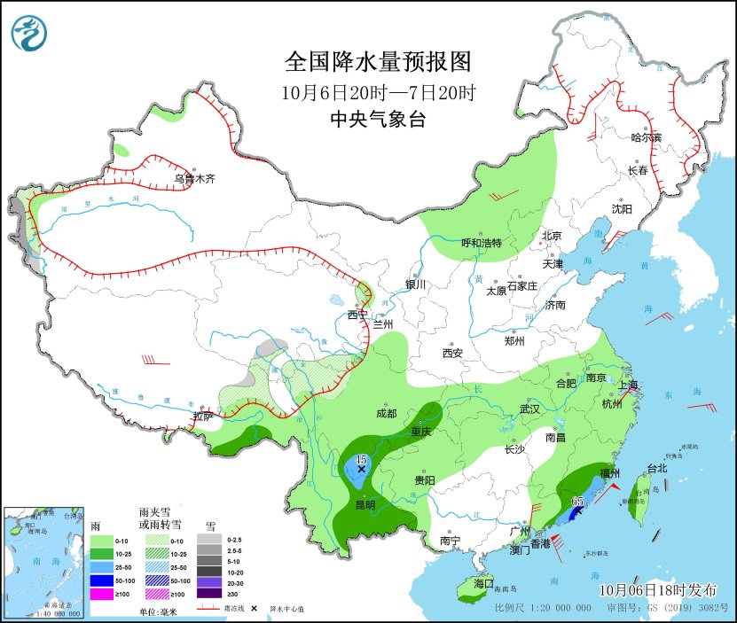
Figure 1 National Precipitation Forecast Chart (from 20: 00 on October 6 to 20: 00 on October 7)
From 20: 00 on October 7 to 20: 00 on October 8,There are small to medium snow or sleet in parts of southwestern Xinjiang, south-central Qinghai and northern Tibet, and there is heavy snow (5 ~ 9 mm) in central Qinghai; There are moderate to heavy rains in parts of southeastern Tibet, central and southern Yunnan, coastal areas in central and eastern Guangdong, northern and eastern Fujian and Taiwan Province Island, among which there are local heavy rains (50-80 mm) in coastal areas in southern Guangdong and southeastern Fujian. There are 6~7 winds and 8 gusts along the coast of Zhejiang, Fujian, Guangdong and the western coast of Taiwan Province Island. There are 6-8 winds and 9-10 gusts in most sea areas of the East China Sea, Taiwan Province Strait and northeastern South China Sea, among which there are 9-10 winds and 11-13 gusts in parts of Taiwan Province Strait and northeastern South China Sea (see Figure 2).

Figure 2 National Precipitation Forecast Chart (from 20: 00 on October 7 to 20: 00 on October 8)
From 20: 00 on October 8 to 20: 00 on October 9,There are small to medium snow or sleet in parts of southwestern Xinjiang, south-central Qinghai and northern Tibet; There are moderate to heavy rains in southeastern Tibet, southwestern Sichuan, central and southern Yunnan, coastal areas of Guangdong and Fujian, and parts of eastern Liaoning, with heavy rains (50-60 mm) in the southern coastal areas of Guangdong. There are 6-8 winds and 9-10 gusts in the southern part of the East China Sea and the Taiwan Province Strait, and 7-9 winds and 10-11 gusts in the northern part of the South China Sea and the north sea area of Beibu Gulf (see Figure 3).

Figure 3 National Precipitation Forecast Chart (from 20: 00 on October 8 to 20: 00 on October 9)